- GMS.NET offers you an easy way to download big Google Maps on your PC as JPEG, PNG-8, PNG-24, BMP or Targa files.
- GMS.NET is light.
- GMS.NET runs on all modern Windows Operating Systems.
- GMS.NET is the successor of GMS (Google Map Saver)
- GMS.NET is free.
However if you consider this piece of software a donation would be welcome. You can use the button bellow to donate with PayPal:
Quick Step by Step Tutorial
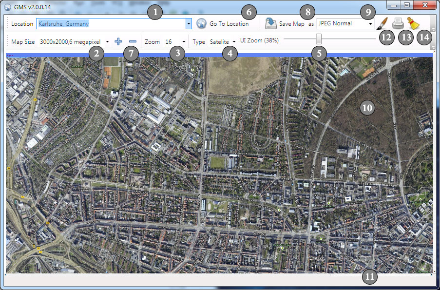
- Give a Point of Interest (POI). Here are some examples:
- New York, US
- Karlsruhe, Germany
- Niagara Falls, US
- 1600 Amphitheatre Parkway, Mountain View, CA 94043
- Choose the desired resolution.
- Please note that this is an approximate resolution.
- The captured picture will have most likely a little bit more horizontal and vertical resolution.
- Use other graphic tools to crop the unnecessary frame.
- Please do not remove the Watermarks.
- Choose the Zoom Factor if necessary, otherwise you could jump on step 6.
- Greater numbers gives you more detail
- On some places zoom levels 18, 19 and 20 are not producing any output in Sat mode.
- Choose the Map output type if necessary, otherwise you could jump on step 6.
- Map – Map only, streets, street names, places, etc.
- Satellite – Satellite imagery
- Zoom UI
- It is recommended that you zoom out the map on big resolution so that you can see the entire map
- When you have an overview over the entire map you can double check when the map is completelly downloaded.
- You are ready to access the Google servers for the maps so, please press GO!
- Once you press GO! consider waiting a little bit until all the tiles are downloaded.
- Depending of selected resolution and you internet connection speed it can take a while
- Consider using Zoom UI slider to zoom the entire map inside the window.
- After all tiles are downloaded use the save button.
- By using Plus/Minus buttons you can add your own resolution into the tool.
- Type in a custom resolution into the resolution box in the following format: 1234×321,A Custom Resolution
- Press Plus button to add the resolution to the list
- Use Minus button to remove a resolution from the list
- You can save the map in the specified format (9) after the map finished downloading
- Before saving the map consider adjusting the output resolution.
- Consider that the resolutions above 10.000 x 10.000 pixels are very problematic
- For huge map use a Windows 64 bit system with plenty of RAM.
- If you select big resolution consider selecting Targa or BMP.
- If you run out of resources it may happen that you need to restart the application and repeat the operation using BMP or TARGA export.
- The watermark is there just to be sure that you read the license and agreed with it.
- Use the embedded Google Maps controls to adjust and navigate the map, once you pressed the GO! button
- Click inside the Map, once, to hide the google login info. On some PC you may get additional bogus icons.
- If you don’t want the location bubble to be shown on the exported map simple scroll in the middle of the map and close it.
- Use the embedded Google Maps controls to adjust and navigate the map, once you pressed the GO! button
- Before saving the map scroll the map and double-check if was completely downloaded.
- Observe the status bar from time to time
- If there is no more activity here most likely your map is ready for saving.
- For big maps use better the ZOOM UI and observe the entire map.
- Edit the map in MS Paint
- After storing the file the application will automatically load it in MS Paint.
- Preview and Print
- Preview and Print the map.
Here is a list of common problems and some solutions:
- If you get a dialog showing Script Error you can try few times to ignore it. If doesn’t stop you may need to close the application.
- You you run out of memory resources you may need to restart the application and decrease the output resolution
- Internet Explorer 7+ is required
- Windows 7 and newer is recommended.
- GMS.NET may work on MAC OSX or Linux (with Wine) if you solve the issues with the Internet Explorer 6 IFRAME.
[ad#gms]
PLEASE READ THE GOOGLE MAPS SAVER .NET LICENCE (GMS.NET) BEFORE DOWNLOADING…
GMS.NET LICENSE
GMS.NET IS FREE BUT THERE IS NO WARRANTY!
THE PROGRAM IS DISTRIBUTED IN THE HOPE THAT IT WILL BE USEFUL,
BUT WITHOUT ANY WARRANTY. IT IS PROVIDED “AS IS” WITHOUT
WARRANTY OF ANY KIND, EITHER EXPRESSED OR IMPLIED, INCLUDING,
BUT NOT LIMITED TO, THE IMPLIED WARRANTIES OF MERCHANTABILITY
AND FITNESS FOR A PARTICULAR PURPOSE.
THE ENTIRE RISK AS TO THE QUALITY AND PERFORMANCE OF THE PROGRAM
IS WITH YOU. SHOULD THE PROGRAM PROVE DEFECTIVE, YOU ASSUME
THE COST OF ALL NECESSARY SERVICING, REPAIR OR CORRECTION.
IN NO EVENT UNLESS REQUIRED BY APPLICABLE LAW THE AUTHOR WILL
BE LIABLE TO YOU FOR DAMAGES, INCLUDING ANY GENERAL, SPECIAL,
INCIDENTAL OR CONSEQUENTIAL DAMAGES ARISING OUT OF THE USE OR
INABILITY TO USE THE PROGRAM (INCLUDING BUT NOT LIMITED TO LOSS
OF DATA OR DATA BEING RENDERED INACCURATE OR LOSSES SUSTAINED
BY YOU OR THIRD PARTIES OR A FAILURE OF THE PROGRAM TO OPERATE
WITH ANY OTHER PROGRAMS), EVEN IF THE AUTHOR HAS BEEN ADVISED
OF THE POSSIBILITY OF SUCH DAMAGES.
IF YOU AGREE WITH THIS LICENSE YOU CAN INSTALL/RUN GMS.NET BY
PRESSING ONE OF THE FOLLOWING LINKS:
If you experience any problems with installation/run uninstall any previous version
of GMS.NET and run the installer again.
Now it seems to work properly!!! thank you!!!
How can i remove the names of the streets when I am on satelite – tehre is not such an option?
Can’t install – Microsoft.mshtml GAC error.
New update on GMS.NET
– Fixed GAC error
– Added a very useful feature: Zoom UI
Install from here.
@MIRA: I need to figure out the new map type on Google Maps. They’ve changed that too.
Thanks very much – I hope you figure it out! I use the program a lot so it will be good to have it as good as it was before.
Please add more maps sizes or let us enter custom map size values. Thanks!
type in your desired resolution in the edit box and press the + button to add that resolution to the list
New update on GMS.NET (r19)
– Added support for 64bit
– Fixed persistency
It is recommended to uninstall before installing the new version.
Hello,
Like MIRA, I need it without street name, do you think it’s possible ?
Thank’s for your good work !
According to the new Google Maps api this is not possible anymore.
I, too, would like your program to work without labels in the Satellite picture. Looking at googles forums I see that many people have been complaining about this for over a year so it’s not likely to get fixed. However, I did notice this other site http://www.maps-for-free.com/ is able to display the maps without labels – are they using the api or something else? I only wish I had found your tool earlier. 😉 Oh, and BTW, what is that little devil link for? It says “Add from custom URL” – what does that mean?
Well… Try to add the http://www.maps-for-free.com/ url instead of the bing url and tell me the result 🙂
Update: Version 2.0.0.20 of GMS.NET supports OpenStreetMap
Feel free to download and give feedback
144 MPixel Map from OpenStreetMap created with GMS.NET
https://www.flickr.com/photos/unsmecher/14233155105/sizes/o/
It seems that TIFF format is more optimized for huge map sizes so please save as TIFF for big resolution.
Thanks
I found that color of map little bit difference to original
Can I original back to original?
I try TIIF, PNG, BMP got same result
@Alex: Can you be more specific? OpenStreetMap is a second option and it has of cours different colors. Google Maps are by default selected in the Engine combobox.
please see the picture http://tinypic.com/r/24n318g/8
left side is GMS screen, the color is same as webbrowser.
right side is saved image.
the saved image is look like lighter than browser screen.
May I know it is expected or something wrong on my setting?
Thanks
@Alex: Try to save as TIFF, BMP or JPEG High. Are you experiencing the same problem?
Very nice application; my compliments.
However, unfortunately satellite image does not work. I would like to use a satellite image in my vacation album.
In the application there are two options “satelite”; can it be that it tries to call “satelite”, while my region settings that calls the google API does not recognize this? I tried entering “satellite” manually, but that does not work either.
Is this something you can fix? Would be really appreciated.
is there any chance you could add a feature such that the images grabbed by GMT are already georeferenced?
@MICHIEL: switch to google maps and click the small icon placed in the bottom-left corner of the map.
@LANZE: can you be more specific? did you mean geo tagged?
Your donate button doesn’t work properly. I’d like to donate but once I’m logged into the paypal there is no recepient provided.
Hope it works now.
Sattelite / Terrain not working – all type i try is only pure map
I’m only able to use the GoogleMaps “map” option. Neither of the two “satelite” options work (misspelled in GMS.NET by the way).
Awesome app, keep up the hard work on it.
takes me really too long to load maps on location manually with http://www.maps-for-free.com/ am I missing a way to do it faster?
It is a useful software. Please add a “quick preview of the map” feature that is going to be saved. Since it takes so much time to load high resolution map and see whether the zoom and frame are chosen properly or not.
Today I am trying GMS.NET for the first time. 2.0.0.20 on Windows 7 64bit. I can download and see the map great, but when I save, it doesn’t seem to create a file. I’m tried JPEG, PNG, BMP, GIF, TIFF. I did 1920 x 1080 for easy testing. I’d be happy to donate $40 if I can get this to work for planning my bike trip.
I’m having the same problem as Mike, the previous commenter. I can view the map at any resolution, but even the smallest resolution will not save a file locally, nor of any other resolution I tried (in case that was the issue).
Does anyone have any suggestions? I am running 64-bit Windows 7,
To anyone else who is struggling with the satel(l)ite issue, I was having that same issue until I started fiddling around with the zoom settings and on one of the settings I noticed a tiny square that Decoder said about (13/7/14). It really was tiny on mine and I didn’t have it or couldn’t find it at first
Heya
I’m stugling a little bit. I want to type in W+N coords I got from google earth. Then I want 20km square capture at 40kx40k resolution. The problem is that I cant type in the coords and get to the right spot. It always give me out some crazy result. Can some one please help me out? I also cant even capture any spot at 20k. It just dont let me :((( Other than that this app appears to save my live if I can get it to work !
GMS seems to work on decimal co-ordinates, use a website such as http://www.earthpoint.us/Convert.aspx to convert your lat/long into the decimal format.
As for your specific requirements, I *think* you’re stuck with the presets. When I was doing my larger images I saved 4 x 8K images and stitched them together myself
ottimo
How do I remove the labels? I’ve trying to get a map without the labels. I used to be able to, and I can get rid of the labels over on google maps… Am I missing something?
Hi,
I run a small NGO and need to download some hybrid google images (satellite) for remote areas in Pakistan. Can you please help? Your software is good but only downloads maps. Those far flung and hard to reach places dont have any roads etc
I previously used gmapcatcher but after google changed its API, that has stopped working (its also open source)
Can you help us please? I might be able to send a small donation (20 or 30$)
regards
Hdaackda
Where the map should be displayed it’s just white. If I drag the map around I can see it appear at the edges for a split second and then it goes white again…
The Satellite type not work
Hi Decoder, I have a little issue with GMS.
I need to save a set of hi-res images in order to stitch them, and I created and saved a new resolution (15360×9600,WHUXGA); when I load the map, my result is a standard map in 7680×4800 resolution over a 15360×9600 grey background, and sometimes there is some black squares in the image.
How I can solve this problem?
Thanks!
Awesome software!!! is it possible to load Google My Maps in GMS.NET? So that I can create/edit a map and save it in GMS. I tried to copy and paste the URL of My Maps in the “Add from custom url”. It doesn’t work.
Thanks for your precious software,
i noticed one problem with gmsnet, with map engine in googlemaps, the type rollout don’t make any change. i can choose from map, satelite, satelite, terrain but nothing happen. For see terrain i need to clik, in the map left lower corner, the terrain thumbs and it work. Unfortunately the map is with label, there is a way to delete them?
many thanks
@Decoder guess Lance meant, that he wants a tif which is a GeoTIFF. I also would appreciate that, at the moment ur tool is just a better screenshot tool to me.
GMS doesn’t work anymore from yesterday, now i get only a white page (in the status bar below i can clearly see a “Done: about:blank” answer from the application).
I cannot use GMS.net at work :\
does anyone have an alternative?
I’ll write again ’cause i tried also GMS.net at home and it doesn’t work, too…
I guess Google has messed up something with your app…cause in other sites (like https://developers.google.com/maps/documentation/embed/start ) the iframe works (also with every browser).
As for now, both GMS and GMS.net aren’t working, unfortunately, at all. 🙁
The program give me an error on google maps:
You are using a browser that is not supported by the Google Maps JavaScript API. Consider changing your browser.Learn more Dismiss.
I have a windows 10 pro version 1703, compilation 15063.674
You are using a browser that is not supported by the Google Maps JavaScript API. Consider changing your browser.
I am using windows 10 and above error came out when I Go to Location!
Same problem here, Browser not supported by the google maps javascript API.Already tried a Registry trick, that worked once, but not able to get satelite images.
Educational video placed on YouTube where Google Earth image quality can be viewed with gmsnet v 2 please Put your link
When I press Goto Location appear this message “You are using a browser that is not supported by the Google Maps JavaScript API. Consider changing your browser.” but I use Mozzilla and it is set to default broswer. I deactivated internet explorer but the message still appear.
Help