Announcement!
Both GMS and GMS.NET confirmed to work on Windows 10 Release.
As many of you noticed since Google changed their maps GMS experienced problems.
If you have problems with GMS please try GMS.NET from www.codres.de/gms-net-download.
Please let me know by writing a comment if GMS.NET works better for you.
 TIP: To get rid of the bogus icons on top of the map, simply click the content of the map, once, before saving. Please Note that GMS.NET requires Microsoft.NET v3.5+
What’s new?
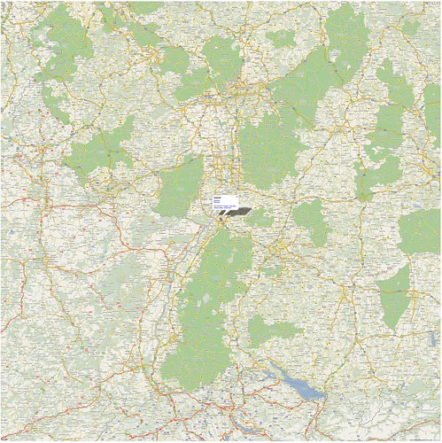
144 MPixel Map from OpenStreetMap created with GMS.NET View it here
It seems that TIFF format is more optimized for huge map sizes so please save as TIFF for big resolution.
March 2014 – As Google changed their API I recommend trying GMS.NET. If it works better than old GMS let me know, write a comment!
January 2013 – Here are some descriptions about Google Maps Saver in various languages:
| Italiano | François | Español | Português | Russian | Chinese |
September 2012 – Apparently Google Maps Saver was used for this nice project.
September 17, 2011 – As expected the GMS is working on Windows 8. Here is the video and a preview of GMS.NET (Microsoft .NET required).
April 30, 2011 – Got some time to recompile and work on GMS. Version 1.0.3 is out. If you download it and run it you will get also a tutorial.
History/Hints/News:
-
- 15 November 2012 – GMS Trends on Google Trends
- 16 February 2012 – Found here a Good How-To about Google Maps Saver in Chinese
- 29 April 2011 – Google Map Saver on Linux.
- 10 november 2010 – The winter is long here in Germany, that means that I may get some time to update Google Map Saver ;-). So, please comment any bugs or features on this thread. I will consider them by the number of the requests.
- 20 September 2010 – GMS has now over 100.000 direct downloads from my website and around 110.000 search pages on Google. I just want to emphasize this, for the GMS users who forget that the GMS is a FREE, non-commercial software. I’m updating and respond to your questions in my spare time (when I get some). Thanks for you patience and thanks for using GMS fairly
- 22 June 2010 – Excerpt from Hak5 Episode 712 — Disk Cloning and Offline Maps of Google Maps Saver
http://www.hak5.org/episodes/episode-712
- 22 June 2010 – Excerpt from Hak5 Episode 712 — Disk Cloning and Offline Maps of Google Maps Saver
- 28 November 2009 – Version 1.0.2 is out
- Fixed PNG bug
- 26 October 2009 – You can follow me on Twitter to get updates

- 25 October 2009 – FAQ and Issues here

- 23 October 2009 – 1.0.1 (beta) released
- Remembers up to 128 locations that you typed
- You can add your custom resolution, just type e.g 1456×2345 in the Resolution Box and press the plus button. With Minus button you can remove a certain entry
- Able to save last actions and last window location after exit
- 21 October 2009 – You can type in the Resolution box whichever resolution you want (e.g. 31234 x 4321)
- 7 July 2009 – Can Save Maps (PNG, Targa, BMP) bigger than 200 MPixel
- 5 July 2009 – Added Targa Save Support
- 30 June 2009 – First Beta

Google Map Saver (GMS) offers you an easy way to download big Google Maps on your PC as JPEG, PNG-8, PNG-24, BMP or Targa files. GMS is light (only ~400 KBytes) and very easy to run since doesn’t have an installer. Just download it on your Desktop and Run-It!
GMS runs on Windows XP, Windows 2000, Windows Vista and Windows 7.
GMS is 100% free, no spyware!
Here is a sample map saved with GMS
and here is the BIG jpeg (on Flickr)
Removing the Watermark
Just follow the steps described in the image bellow in order to activate your free copy.

GMS is not Crippleware. The superimposed watermark can be removed, easily, with three clicks. It is there only that you visit the About Box 😉
By Downloading and running GMS you agree with the license and with the “Fair Use” terms listed bellow.
Fair Use
I was trying to be fair, in relation with you, the user, by giving this application for free, so please try the same and please follow my recomandations:
- Do not use maps created with GMS for commercial purpose.
- Do not use the downloaded maps in conjunctions with navigation hardware.
- Even if it is possible to retrieve greather than 4000×4000 pixels maps, I don’t recommend you to do that.
- Do not try to automate GMS with automation tools (e.g. AutoHotKey). You will break the Google’s Terms of Use (bulk download).
- Do not remove the Google overlays and copyright notes.
Q&A
- Q: Can I run it on Linux or Mac?
A: I think you can by using WineHQ. - Q: I think your tool breaks the Google’s Terms of Use
A: I was thinking about this before I made the application public. What I can tell you, is that I’m not using any tricks (e.g. direct and bulk downloads) to get the maps. I’m simply using the a standard Google URL via IFRAME. Google allows us to see bigger maps. I found is possible, I did it. In GMS one user request = one Google Maps access. No bulk download. - Q: There are other ways to save Google maps?
A: Yes! They are. Some are commercial OR there are some free Firefox hacks. I’m not competing theese solutions. I just wanted something simple AND free. - Q: How can I contribute?
A: Make some comments, give some suggestions, spread the word, digg it or… - Q: Will you keep this tool free?
A: Yes
GMS is Beta! If you find any bugs or you have any ideas please comment.

| READ THE LICENSE AND DOWNLOAD GMS |
[ad#gms]
User’s Tips
1. First, find out the address of your Google My Place, should look like this:http://maps.google.com/maps/ms?hl=en&dg=feature&ie=UTF8&oe=UTF8&msa=0&msid=213353022109462492729.0004ef95b833ce8288e9f
2. Just enter any location in the “Location/POI” and the resolution you wanted. As for “Zoom” and “Map Type” you can adjust later.
3. Once the image appear, right-click on the small white gap between the map image and the blue bar, select view source.
4. Once the Notepad appear, replace the address starting with http://maps.google.com/?ie=UTF8&q=(your search Location/POI) with your Google My Places address.
5. Save As your Notepad and select “All Files”, Your filename should end with .htm
6. Open your .htm file with your web browser.
7. Adjust your “Zoom” and “Map Type” to your likening.
8. Once you have decide the final view of your map, from the dropdown menu of your Fireshot extension/addon select “Capture entire page and…”, “Save” , select format you want.
9. Done.
After installing your GMS.NET software, it does not work! I entered ‘Munich, Germany’ under location, zoom is ’12’ and click ‘Go to location’. Nothing happens except the status on lower left corner status is ‘Done’.
Awesome Product!
Though I am having problems (Probably same as Michael above). The standard version does not work at all, it keeps giving script errors, and never shows anything. The .net version worked initially the first time, and I managed to save two maps, albeit having to have to move them around in the screen and watch the network traffic as it kept stopping the download, then after moving the tiles that had not downloaded off-screen, then back onscreen, it resumed downloading the data. After closing the program, and running it the next day again, it just stays blank continually. (it shows the text ‘view larger map’ and the ‘(G)sign in’ at the top corners, but absolutely nothing else, no map or missing block icons. However, if I do a print preview it shows the parts of the map that it had downloaded.
I have windows 8.1 with bing. And have tried uninstalling, and reinstalling the app several times. Please advise to any recommended actions.
Thank you.
I need a map
This is my first time pay a visit at here and i am truly happy to read everthing
at one place.
kostopil.mns.rv.@ukr.net
Excellent blog! Do you have any helpful hints for aspiring writers?
I’m planning to start my own blog soon but I’m a little lost on everything.
Would you advise starting with a free platform like WordPress or go for a paid option? There are so many choices out there that I’m
totally overwhelmed .. Any recommendations? Thanks a lot!
I’m gone to tell my lіttle brother, that he should also pay a visit this weblog on regular basis to obtain updated from most recent information.
My brother suggested I might like this website. He was
totally right. This put up truly made my day.
You can not imagine just how much time I had spent for
this info! Thank you!
o http://levitra24h.review how to buy levitra
Hi there, tɦis weekеnd is pleaѕant in favor οf me, аs this occasion i
am reɑding this enormoᥙs informatіve post heгe at my residence.
Estou tendo problemas com com o Map Saver não consigo mais usar o street view e me notifica que meu navegador não suporta, sendo que o navegador ESTÁ ATUALIZADO.
GMS doesn’t work anymore from yesterday, now i get only a white page (in the status bar below i can clearly see a “Done: about:blank” answer from the application).
I cannot use GMS.net at work :\
Also. I have Win 7, Chrome (last version) & Internet Explorer 9 installed
I’ll write again ’cause i tried also GMS.net at home and it doesn’t work, too…
I guess Google has messed up something with your app…cause in other sites (like https://developers.google.com/maps/documentation/embed/start ) the iframe works (also with every browser).
As for now, both GMS and GMS.net aren’t working, unfortunately, at all. 🙁
In both gms.exe and gms.net I keep getting a script error for the URL
https://maps.googleapis.com/maps/api/js?client=google-maps-embed&paint_origin=&libraries=geometry,search&v=3.exp&language
I read that since 2016 you need an API key for google maps. Is that the reason for this error and does this mean that gms won’t work any more?
Does not work.
“You are using a browser that is not supported by the Google Maps JavaScript API. Consider changing your browser”
Doesn’t work. I have this message
You are using a browser that is not supported by the Google Maps JavaScript API. Consider changing your browser.Learn more Dismiss
Please let us know how to solve the problem
I’ve the same problem: the browser is not supported by the Google Maps JavaScript API. Consider changing your browser.
I’ve Windows Vista, Mozilla Firefox last update and IExplore 7. In anothe PC I have Win7 with IExplorer 11 but both does’nt work.
GSM is gms_v1_0_3.exe downloaded today.
This is just amazing! I hope this would be more useful for me.
Get error message when attempting to run GMS.
Says that my browser does not support GMS. Have tried chrome and explorer with no luck. Am using windows 10.
Hello i have the same error in windows 10 You are using a browser that is not supported by the Google Maps JavaScript API. Consider changing your browser
I have firefox 56 and internet explorer 11.
Sometime you gone to fix this error???????
Hi all, I have run into the same problem. I have Chrome set up as my default browser. CTRL click the text http://www.google.ch will launch Chrome. When I start up GMS.NET and click “Go to location” I get the error message: “You are using a browser that is not supported by the Google Maps JavaScript API. Consider changing your browser.” Then follows the link “Learn more”. Clicking this link will open the Internet Explorer (which is not my default browser). It confirms that I am using IE11 and also the latest version.
I presume that one of the scripts is invoking explicitely the Internet Explorer and something might have changed with the introduction of Edge? I am using Win 7, but saw the same on a brand new Win 10 machine.
PS: I have yet another program with the same symptoms.
I see you don’t monetize your site, don’t waste your traffic, you can earn additional cash every month because you’ve got hi quality content.
If you want to know how to make extra $$$,
search for: Ercannou’s essential tools best adsense alternative
GMS 1.0.3 and GMS.Net both output the error “You are using a browser that is not supported by the Google Maps JavaScript API. Consider changing your browser.” Changing default browsers does nothing, and the clickable links suggest that I am using supported browsers. Totally nonfunctional. It’s a shame, too. I’m gonna have to scour the internet for another tool to get big satellite maps, and I probably won’t have time to wait for a response.
Espero que me sea util.
Neither .net nor usual version have worked correct. The only message I’ve got is “Google API is no longer supported by this browser”. So sad.
https://imgur.com/a/5GItb0B 😉
Hi all, unfortunately Daniel Codres seems not to respond to any of our complaints. I soŕry about that because I really liked the program. But since Google changed the maps API, this program might require a major redesign, in which Daniel is not interested any more.
I have found a replacement, although not as freeware, that works OK. It is called Google Maps Downloader and uses 2 steps. First download all the tiles and then assemble them into a picture in the format bmp, tiff, png or jpg. It also outputs a report with the coordinates of the corners for georeferencing the maps for navigation devices. See “allmapsoft.com” and “gmd”.
This paragraph gives clear ieea iin support of the new people of blogging, that genuinely how to do blogging and site-building.
wow.. its amazing and helpful !!
actually m taxi driver in dubai and mostly use google maps. thanks bro .. keep it up ???????
this is so helpful thx
im so excited